R | Training
R Camp
This series of workshops teaches the basics of importing data, using new packages, cleaning and summarizing data with tidy tools, and using ggplot2 to create charts, maps and other data visualizations.


- Become a Jedi scrap scavenger
- Project launch
- Create a new project and R script
- Install R packages
- Create variables, lists, data frames
- Read data into R
- Arrange, select and filter data
- Plot the data!
Packages: readr, dplyr
Planets visited: Jakku
- The
ggplotsandwich - Data cleaning
- Data transformations
- Add new columns and convert units
- Summarize data
- Group the data
- Answers for each monitoring site or group
Packages: dplyr,
Planets visited: Jakku
- Working with Dates
- Join 2 data tables
- Calculate new column values
- Save data
- More plots!
Packages: ggplot2, lubridate
Planets visited: Endor
- Conditions:
ifelse()do this - Summarize by group
- Even more plots
- Scatter plots
+box plots - Add titles, colors, and labels
- Reference lines
- Scatter plots
- Save plots
- Explore Your data
- Tidy your data
- Plot your data
Packages: ggplot2, readxl Planets visited: Ahch-To
R Workshops
Each of these workshops dives into more detail on a common data anlaysis task.
- Collapse data spread across many columns
- Read an entire folder of files and combine into 1 table
- Order plots from highest to lowest
- Parse dates into seasons, months, quarters, or day of the year
Packages: tidyr, readxl, lubridate, forcats
- Connect to Oracle databases
DELTA/TEMPO
- Explore datbase tables
- Read data from different schemas
- Join tables
Packages: RODBC, dplyr
- Read and save shapefiles
- Convert coordinate projections (ex.
Lat/LongtoUTM) - Load reference maps
- States, counties, ZIP Codes
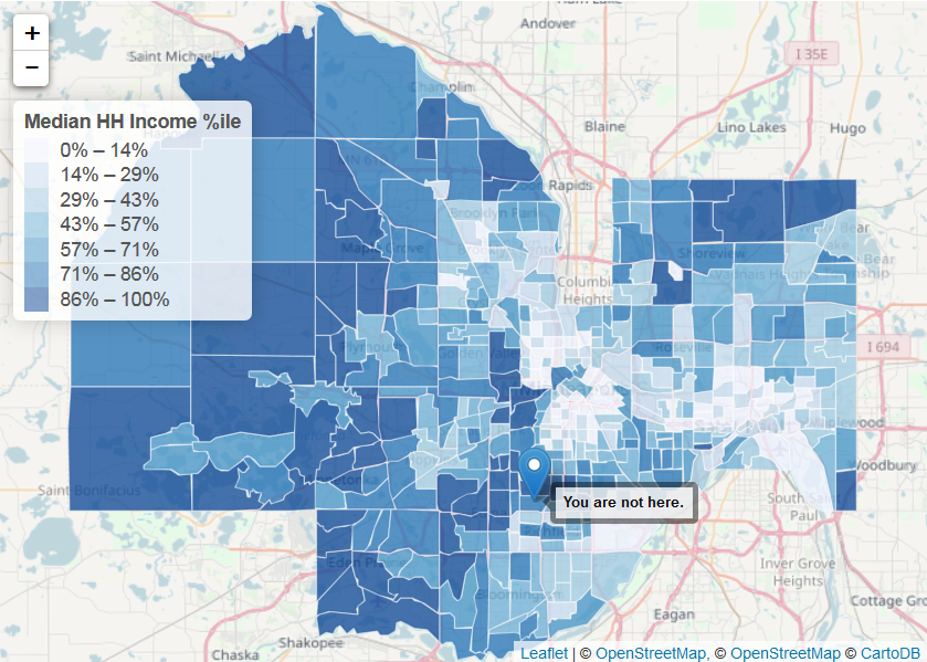
- Build interactive maps
Packages: leaflet, sf, tidycensus, tigris

- Read CSVs from the web
- Connect to FTP sites
- Other web APIs
- Scrape text from webpages
Packages: dplyr
- Read & write data from other stats programs
- SAS, SPSS, & Stata
- MATLAB
- Systat / SigmaPlot
- Minitab
Packages: haven, foreign
- Read and save shapefiles
- Convert projections
Lat/LongtoUTM
- Load reference maps
- States, counties, ZIP Codes
- Build interactive maps
Packages: readr